Effects Watches and warnings Storm surge -
Notable storms Retired hurricanes (Atlantic - Pacific) A
tropical cyclone is a meteorological term for a
storm system characterized by a
low pressure center and
thunderstorms that produces strong wind and flooding rain. A tropical cyclone feeds on the heat released when moist air rises and the water vapor it contains
condenses. They are fueled by a different heat mechanism than other cyclonic windstorms such as
nor'easters,
European windstorms, and
polar lows, leading to their classification as "warm core" storm systems.
The adjective "tropical" refers to both the geographic origin of these systems, which form almost exclusively in
tropical regions of the globe, and their formation in
Maritime Tropical air masses. The noun "cyclone" refers to such storms'
cyclonic nature, with
counterclockwise rotation in the
Northern Hemisphere and clockwise rotation in the
Southern Hemisphere. Depending on their location and strength, tropical cyclones are referred to by various other names, such as
hurricane,
typhoon,
tropical storm,
cyclonic storm, and
tropical depression.
While tropical cyclones can produce extremely powerful winds and torrential
rain, they are also able to produce high waves and damaging
storm surge. They develop over large bodies of warm water, and lose their strength if they move over land. This is the reason coastal regions can receive significant damage from a tropical cyclone, while inland regions are relatively safe from receiving strong winds. Heavy rains, however, can produce significant flooding inland, and storm surges can produce extensive coastal
flooding up to 25
mi (40
km) from the coastline. Although their effects on human populations can be devastating, tropical cyclones can also relieve
drought conditions. They also carry heat and energy away from the tropics and transport it towards
temperate latitudes, which makes them an important part of the global
atmospheric circulation mechanism. As a result, tropical cyclones help to maintain equilibrium in the Earth's
troposphere, and to maintain a relatively stable and warm temperature worldwide.
Many tropical cyclones
develop when the atmospheric conditions around a weak disturbance in the atmosphere are favorable. Others form when
other types of cyclones acquire tropical characteristics. Tropical systems are then moved by
steering winds in the
troposphere; if the conditions remain favorable, the tropical disturbance intensifies, and can even develop an
eye. On the other end of the spectrum, if the conditions around the system deteriorate or the tropical cyclone makes landfall, the system weakens and eventually dissipates.
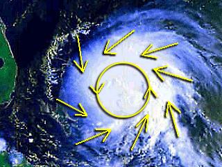
Physical structure Rainbands are bands of showers and thunderstorms that spiral cyclonically toward the storm center. High wind gusts and heavy downpours often occur in individual rainbands, with relatively calm weather between bands. Tornadoes often form in the rainbands of landfalling tropical cyclones.
Banding A strong tropical cyclone will harbor an area of sinking air at the center of circulation. If this area is strong enough, it can develop into an
eye. Weather in the eye is normally calm and free of clouds, though the sea may be extremely violent.
Eye and inner core The size of a tropical cyclone is determined by measuring the distance from their center of circulation to their outermost closed
isobar. If the radius is less than two
degrees of latitude (120 nm, 222 km), then the cyclone is "very small" or a "midget." Radii of 2–3 degrees (120–180 nm, 222–333 km) are considered "small." Radii between 3 and 6 latitude degrees (180–360 nm, 333–666 km) are considered "average sized." Tropical cyclones are considered "large" when the closed isobar radius is 6–8 degrees of latitude (360–480 nm, 666–888 km), while "very large" tropical cyclones have a radius of greater than 8 degrees (480 nm, 888 km). Other methods of determining a tropical cyclone's size include measuring the radius of gale force winds and measuring the radius of the central dense overcast.
Size A tropical cyclone's primary
energy source is the release of the
heat of condensation from water vapor
condensing at high altitudes, with
solar heating being the initial source for evaporation. Therefore, a tropical cyclone can be visualized as a giant vertical
heat engine supported by mechanics driven by physical forces such as the
rotation and
gravity of the
Earth.
Mechanics Main articles: Tropical cyclone basins, Regional Specialized Meteorological Centre, and Tropical Cyclone Warning Centre Major basins and related warning centers Main article: Tropical cyclogenesis Formation Worldwide, tropical cyclone activity peaks in late
summer, when the difference between temperatures aloft and sea surface temperatures is the greatest. However, each particular basin has its own seasonal patterns. On a worldwide scale, May is the least active month, while September is the most active.
Times The formation of tropical cyclones is the topic of extensive ongoing research and is still not fully understood. While six factors appear to be generally necessary, tropical cyclones may occasionally form without meeting all of the following conditions. In most situations,
water temperatures of at least 26.5 °C (80 °F) are needed
Locations Movement and track Although tropical cyclones are large systems generating enormous energy, their movements over the Earth's surface are controlled by large-scale winds—the streams in the Earth's atmosphere. The path of motion is referred to as a tropical cyclone's
track and has been analogized by Dr. Neil Frank, former director of the
National Hurricane Center, to "leaves carried along by a stream."
Steering winds The Earth's rotation imparts an acceleration known as the
Coriolis Effect,
Coriolis Acceleration, or colloquially,
Coriolis Force. This acceleration causes cyclonic systems to turn towards the poles in the absence of strong steering currents.
 Coriolis effect
 When a tropical cyclone crosses the
subtropical ridge axis, its general track around the high-pressure area is deflected significantly by winds moving towards the general low-pressure area to its north. When the cyclone track becomes strongly poleward with an easterly component, the cyclone has begun
recurvature. Interaction with the mid-latitude westerlies See also: List of notable tropical cyclones and Unusual areas of tropical cyclone formation Officially,
landfall is when a storm's center (the center of its circulation, not its edge) crosses the coastline.
Landfall Dissipation A tropical cyclone can cease to have tropical characteristics through several different ways. One such way is if it moves over land, thus depriving it of the warm water it needs to power itself, quickly losing strength. Most strong storms lose their strength very rapidly after landfall and become disorganized areas of low pressure within a day or two, or evolve into
extratropical cyclones. While there is a chance a tropical cyclone could regenerate it managed to get back over open warm water, if it remains over mountains for even a short time, it can rapidly lose its structure. Many storm fatalities occur in mountainous terrain, as the dying storm unleashes torrential rainfall, leading to deadly
floods and
mudslides, similar to those that happened with
Hurricane Mitch in 1998. Additionally, dissipation can occur if a storm remains in the same area of ocean for too long, mixing the upper 30 meters (100 feet) of water. This occurs because the cyclone draws up colder water from deeper in the sea through
upwelling, and causes the water surface to become too cool to support the storm. Without warm surface water, the storm cannot survive.
Factors In the 1960s and 1970s, the
United States government attempted to weaken hurricanes through
Project Stormfury by
seeding selected storms with
silver iodide. It was thought that the seeding would cause
supercooled water in the outer rainbands to freeze, causing the inner eyewall to collapse and thus reducing the winds. The winds of
Hurricane Debbie—a hurricane seeded in Project Stormfury—dropped as much as 30%, but Debby regained its strength after each of two seeding forays. In an earlier episode in 1947, disaster struck when a hurricane east of
Jacksonville, Florida promptly changed its course after being seeded, and smashed into
Savannah, Georgia.
Artificial dissipation Main article: Effects of tropical cyclones Effects Observation and forecasting Main article: Tropical cyclone observation Observation See also: Tropical cyclone forecasting, Tropical cyclone prediction model, and Tropical cyclone rainfall forecasting Because of the forces that affect tropical cyclone tracks, accurate track predictions depend on determining the position and strength of high- and low-pressure areas, and predicting how those areas will change during the life of a tropical system. The deep layer mean flow is considered to be the best tool in determining track direction and speed. If storms are significantly sheared, use of wind speed measurements at a lower altitude, such as at the 700
hpa pressure surface (3000 meters or 10000 feet above sea level) will produce better predictions. Tropical forecasters also consider smoothing out short-term wobbles of the storm center in order They attribute the lack of improvement in intensity forecasting to the complexity of tropical systems and an incomplete understanding of factors that affect their development.
Forecasting Classifications, terminology, and naming Main article: Tropical cyclone scales Intensity classifications The word
typhoon, used today in the Northwest Pacific, has two possible and equally plausible origins. The first is from the
Chinese 大風 (
Cantonese: daaih fūng;
Mandarin: dà fēng) which means "great
wind." (Huracan is also the source of the word
Orcan, another word for the
European windstorm. These events should not be confused.)
Origin of storm terms Main articles: Tropical cyclone naming and Lists of tropical cyclone names Naming Main articles: List of notable tropical cyclones, List of notable Atlantic hurricanes, and List of notable Pacific hurricanes Notable tropical cyclones See also: Atlantic hurricane reanalysis While the number of storms in the Atlantic has increased since 1995, there is no obvious global trend; the annual number of tropical cyclones worldwide remains about 87 ± 10. However, the ability of climatologists to make long-term data analysis in certain basins is limited by the lack of reliable historical data in some basins, primarily in the Southern Hemisphere. The official record, therefore, could miss storms in which no ship experienced gale-force winds, recognized it as a tropical storm (as opposed to a high-latitude extra-tropical cyclone, a tropical wave, or a brief squall), returned to port, and reported the experience.
Long term activity trends The
U.S. National Oceanic and Atmospheric Administration Geophysical Fluid Dynamics Laboratory performed a simulation to determine if there is a
statistical trend in the frequency or strength of cyclones over time. The simulation concluded "the strongest hurricanes in the present climate may be upstaged by even more intense hurricanes over the next century as the earth's climate is warmed by increasing levels of greenhouse gases in the atmosphere."
Global warming See also: Cyclone, Extratropical cyclone, and Subtropical cyclone In addition to tropical cyclones, there are two other classes of cyclones within the spectrum of cyclone types. These kinds of cyclones, known as
extratropical cyclones and
subtropical cyclones, can be stages a tropical cyclone passes through during its
formation or dissipation.
Related cyclone types Main article: Tropical cyclones in popular culture See also
No comments:
Post a Comment